-
Sample Report



A web based tool for accurately assessing a property's wind resources, taking all local effects into account, determining wind energy potential with a high level of accuracy, at a reasonable price, in a short turnaround time.
-
Check Out the Demo
Wind Analytics™ Demo is online. Preview our wind analysis tool for yourself.
-
Why Choose Wind Analytics™
Wind behaves in complex ways.
Land cover, obstructions, and other local effects greatly affect wind flow. It is essential to accurately account for these effects or risk greatly miscalculating the annual energy output of your turbine and encounter unwanted fatigue issues. Despite this risk, current assessment methods are either too inaccurate, too expensive, or too time consuming to be feasible for the prospective small wind turbine owner.
This is where Wind Analytics delivers.
Wind maps are a useful first step to determine speed and direction at a study location, but are accurate to, at most, 200 meters in open terrain and do not consider any specific obstructions.
Anemometers are useful to track wind behavior over time at a particular point, but do not allow for optimization, can be costly to set up, require considerable time for data collection, and are subject to time series errors.
Wind Analytics addresses these challenges better than any other assessment method by considering one study point at a time, drawing upon 30 years of wind data, and factoring for all local effects.

-
The Wind Analytics™ Process

- Source data is obtained (e.g. 20 year ASOS data) and adjusted for surrounding land characteristics.
- This data is then ported to the target site and local effects are incorporated to determine site's wind conditions.
- Blocking from terrain features, surrounding trees, buildings, and other obstructions is factored into the model.*
- Wind energy potential, estimated power production, and net economic benefit are then calculated for each of the study points selected.
*For a building-mounted application, the following issues are additionally considered: turbulence created by the building edge, blocking issues caused by objects on roof, and increases or decreases in wind speeds based on proposed locations on roof.
-
Wind Value Report
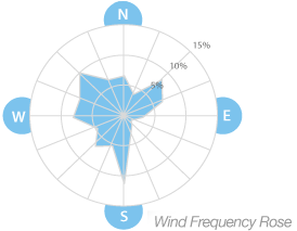
The Wind Value Report gives customers a comprehensive summary of a prospective wind energy project on their property.
Combining our wind pattern data with data from your specific location, the Wind Analytics software accurately estimates: wind energy produced at a given site; optimum rotor positions; turbine power curve; and electricity production (per year, state program initiatives and utility pricing) to determine economic benefit. This information can then be customized and fit into the project manager's overall site assessment report including foundation, electrical, permitting, and zoning issues.
The result is seamless data integration, time savings, and most importantly, a better economic return for the turbine customer.
-
Specifications

Input Data Required:
- Property address or latitude/longitude coordinates
- Study points' latitude, longitude, and height (Unlimited)
- Utility and tariff type
Turnaround Time: 1 Week
Granularity: 1 Cubic Meter
Average Data History: Over 20 Years